-
Sale!

The Explorer 2.0 features DryFlex™ grip for easy handling and comes with a use-anywhere declination scale inside the capsule, a magnifying lens, and base plate map-measuring in inches and scales of 1:62.5k mile & 1:24k USGS scale. The baseplate has a curved-up at the back-end for perfect fit in the hand. The patented red/black North/South lines in the capsule bottom ensures easy and safe settling. The distinct arrow and scales/markings in a clear contemporary font combined with lots of transparency in the baseplate makes navigating easier – when activated in light the luminous markings enable night time navigation. The needle is made from finest Swedish steel with high quality magnetic features.
FEATURES:
- Detachable lanyard with safety-release
- Map measuring scales in 1:24k, 1:62.5k mile, inch (1/20th)
- DryFlex™ Rubber grip allows easy handling of the compass/great grip
- Turnable housing usable with the SILVA 1-2-3 System®
- Declination scale inside the capsule
- Night use / Luminous markings enables night time navigation up to 4 hours once activated by daylight/flashlight.
- Robust material
- Red/black N/S lines in capsule ensures easy and safe settling
- Waterproof
-
Sale!

Accurate in BOTH Northern and Southern Hemispheres
The classic scouting compass with modern updates, the TruArc™ 3 base plate compass is equipped with the TruArc™ Global Needle system in the characteristic form outdoorsmen have trusted for generations. Metric and standard scales, tool-less declination compensation, plus no-frills reliability make this a must for everyone’s outdoor pack.
OVERALL DIMENSIONS:
- 2.5″ x 3.5″ x 0.5″ (6.3 x 8.9 x 1.3cm)
WEIGHT:
FEATURES:
- TruArc™ Global Needle system; 2 degree resolution; Inch/CM scales.
- The TruArc™ Global Needle system is accurate in BOTH Northern and Southern Hemispheres.
-
Sale!

Navigate Like Others Can’t Navigate – Especially in the Dark!
Give yourself the peace-of-mind of having a Cammenga Protractor Compass. Equipped with 6 Tritium micro-lights, it provides continuous illumination for over 12 years. So even in total darkness, you’ll be prepared. Take and transfer bearings, calculate declinations and triangulate with the ultimate confidence. Our Destinate Tritium Protractor Compass’ accuracy provides you with the efficiency and speed you need to navigate any terrain.
Features:
- Map magnifying glass
- 4 map scales for easy navigation on a variety of maps.
- Dial graduations in both degrees and mils.
- Works flawlessly in temperatures ranging from -50 degrees F to 150 degrees F.
- Designed to last with a Navalon baseplate and waterproof, shockproof and sand proof housing.
- Built to the same demanding specifications as our military compasses.
- Incorporates the same military-grade parts and materials found in our Tritium Lensatic Compass.
- Includes lanyard, instruction booklet and black nylon belt pouch.
- Proudly made with the highest quality in the U.S.A.
- NSN: 6605-01-625-2819
- Note: Product may not ship outside the United States.
-
Sale!

Navigate Like Others Can’t Navigate — Especially in the Dark!
Accurate. Hands-free. Tested in the most demanding conditions. Count on the Cammenga Tritium Wrist Compass day or night. Easy-to-read, 10° graduations — enhanced with Tritium Micro Lights — make it invaluable for on-the-go land navigation.
Features:
- Machined aluminum casing for durability.
- Operates flawlessly in temperatures ranging from -25° F to 125° F.
- Induction damping for quick needle stabilization.
- Maintenance-free illumination for over 10 years.
- Heavy-duty nylon wristband.
- Water-resistant.
- Proudly made with the highest quality in the U.S.A.
- NOTE: product may not ship outside the United States
-
Sale!

A must-have for anyone using a GPS, map and compass. Contains 3 clear cards with 1:24,000, 1:25,000, 1:50,000, 1:100,000, and 1:250,000 map scales. Also includes two white cards with survival tips, signaling tips, instructions on how to read a topo map, how to adjust for declination, how to determine distance traveled, how to use UTM with your GPS and compass, and how to travel an azimuth. Printed on 30 Mil plastic credit card stock.
-
Sale!


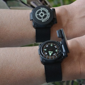
The Escape & Evade® Wrist Compass provides the wearer with a convenient way to get immediate bearings and move out. Designed to be worn on a watch band or other wrist band (not included), but also able to be hung from a paracord lanyard. The flip-top housing protects the compass, and also keeps it in a non-reflective carrying capacity when not used.
The Grade AA cushion-mounted compass is liquid filled, and remains luminous after exposure to sunlight, or even from a red lens micro LED. Submersible and water resistant. A great backup to traditional compasses, GPS, and watch compasses that use power and calibration to function. Get one on and get moving.
FEATURES:
Grade AA
Luminous
Protective flip-top shell
Able to be worn on a lanyard
Cushion-mounted compass is liquid-filled
Fits most sports watchbands (width <14/16 in., <2/16 in. height)
Working temperature range of -20 degrees F to 120 degrees F
Water resistant to 100 ft (30 m)
Made in the USA
1.0″W x 1.1 L x 0.6 D (2.4 cm x 2.7 x 1.6), 0.2 oz (7 g)
-
Sale!

The Escape & Evade® Hard Shell Wrist Compass II provides the wearer with a convenient way to get immediate bearings and move out. A 22mm tactical nylon wrist strap is included and is widely adjustable (fits almost all sizes), but the compass itself is also able to be removed and hung from a lanyard. The compass is cushion mounted and luminous after a short exposure. Liquid filled. Stainless hardware won’t affect compass accuracy.
The hinged cover protects the cushion-mounted 1″ diameter luminous compass and prevents glare. The flip-top hinged housing protects the compass, and also keeps it in a non-reflective carrying capacity when not used.
FEATURES:
- Shielded wrist compass with flip-top hard shell
- Rugged 22mm tactical strap, widely adjustable.
- Liquid filled.
- Grade A
- Easy to read at a glance.
- Water resistant to 30 feet
- Temperature range -20 to 120 F
- Compass dimensions: 1.06″ diameter (27mm), thick with cover closed.
-
Sale!

You don’t always have space for a big fancy compass or GPS; nor do you always need one. What you do need is a reliable and quick way to get your basic directions and move out. Thats where these come in. These button compasses are Grade AA, water resistant to 100ft, and are highly luminous up to 8 hours. Thats a good feature to have in an emergency and survival compass. At 20mm, these can go anywhere you do. Put them in your survival kit, your car, your winter parka,or anywhere. Be ready for when an emergency occurs!
FEATURES:
- Liquid-Filled
- Highly LUMINOUS approximately 7-8 hours
- Working temperature range of -20 degrees F to 120 degrees F
- Water resistant to 100 ft (30 m)
- 20mm diameter x 8.1 mm height
-
Sale!


Ranger Pace Counter: The time-tested way to keep track of distance you’ve traveled in difficult terrain or conditions. Military personnel have used such simple devices for decades as an easy way to keep track of distance traveled during terrain navigation. This becomes essential during night time movement. The beads work by separating them according to a reached pace count to calculate the distance you’ve traveled. (It’s not as hard as it sounds).
1. Place the beads on an easily reachable but secure place on your equipment, such as a shoulder strap.
2. Find your pace count(s): The average used is 65 paces on flat terrain for 100 meters. However, you will want to know your own pace count. A “pace” is counted by every time your left foot strikes the ground while walking at a reasonable stride. (Yes, you can use your right foot if you prefer).
- Measure out 100 meters on flat terrain.
- Walk this distance counting your paces (again, every time your left foot strikes the ground).
- The number you reach at the end of 100 meters is your pace count for 100 meters of flat terrain.
- It is suggested that you get your pace count in several ways: 1) flat terrain, lightly equipped; 2) flat terrain, heavy equipped; 3) medium-steep terrain, lightly equipped, and; 4) medium-steep terrain, heavy equipped. Thus, 4 pace counts are made under these conditions. (Very steep terrain tends not to work well with pace counting). Remember your pace count for each.
- As you age or your physical condition changes, your pace count will likely change as well.
3. Using the Pace Counter:
- Pull all of the beads in the up position.
- The bottom half of the pace counter has 9 beads. Each of these 9 beads represents 100 meters.
- When your pace count for the terrain you are on reaches the mark for 100 meters, draw down one bead from the bottom half of the pace counter.
- When all 9 beads are down, you have traveled 900 meters.
- The top half of the pace counter has 4 beads. Each of these beads represents 1,000 meters (1 kilometer).
- Thus, after you have traveled 900 meters, and all of the bottom 9 beads are down, the next 100 meters traveled will be 1,000 meters of travel (1 kilometer). When that mark is reached, you pull one of the top beads down to mark the 1 kilometer of distance traveled, and pull the bottom 9 beads back to their up position.
- Continue to do this process until all 4 top beads are down, representing 4 kilometers of travel, and repeat the process by moving all of the beads back to their up position.
- Now, the only number you need to keep in your head is the total kilometers traveled after the sequence is complete (4k, 8k, etc.)
- NOTE: Some use the technique whereby the down and up position of the beads is used to determine whether you are on the first set (4k) or second set (8k) — and variations of this. Whatever the method you choose, the beads will enable you to keep very few numbers in your head while you continue to travel, while maintaining an accurate pace count related to distance traveled.
- ALSO NOTE: This method is best used in conjunction with a topographical map. If your map is in “standard” or English / Imperial measurement (feet/miles, etc.) then be sure to know the conversion between metric and English, or, perform your pace count measurements in the format best used in conjunction with your maps.
- FINAL NOTE: This method works best on direct azimuth traveling (straight line distances). If changing direction, it is best to mark the position on your map where you change direction in order to not only measure the distance traveled, but where you are precisely in relation to your map. It will not help you much to perform pace counts while traveling in variable directions without notating the changes on your map.
-
Sale!
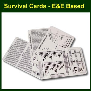

From the folks at ESEE / Izula. Printed on 30 mil plastic credit card stock. Four white cards with survival tips, signaling tips, Morse code, trap and snare diagrams, fire building tips, navigation tips, Escape and Evasion tips and much more. Pretty handy stuff to keep in your kit, your emergency supplies or go bag in case you need it! The focus is on escaping and evading (E&E), and so most pertinent to military members or tactical professionals operating in less than friendly territory. And hey, when you read and know all of the info they provide, you could cut “˜em up and even make decent fishing lures out of them.
FEATURES:
- 30 mil plastic credit card stock
- Survival tips, signaling, Morse code, traps and snares, fire building, navigation, and escape and evasion tips.
- Dimensions (each): 3.25″ x 2″, 30 mil thick.


 We all know that finding your way is a vital component of your survival skills. Having a primary and secondary compass is a wise strategy to employ when venturing out, but don’t neglect some important field-expedient methods humans have used through the centuries. Basic star navigation, shadow-stick methods and others can help you get your cardinal directions in the event your compass fails or is lost. Remember to stay aware of important land marks that you can identify and possibly use to triangulate your position if, in fact, you take a wrong turn.